Diplomacy Map
Diplomacy is an excellent social game from Avalon Hill. In 1997 I wanted to turn it into an online game, but first I had to regularize the conference map of Europe. Computer displays at that time were not as sharp, resolute, and colorful as they are now, and the official map is very busy and hard to read. The game comes with special rules to migitate likely misinterpretations.
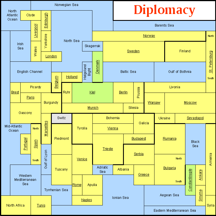
| Legend |
|---|
| Region |
| Navigable Region |
| Sea |
| Impassible |
| Supply Center |
| Thick lines: Regional boundaries |
| Thin lines: National boundaries |
| North South: Separate coasts |
The map was made to these rules:
- It is topologically equivalent to Avalon-Hill's map.
- It is on a uniform grid with vertical and horizontal lines. (This was the most practical form for computer displays.)
- All land regions are strictly rectangular.
- All regions are at least two units in size. (This rule affects Ankara, Clyde, Helgoland Bight, London, Paris, Portugal, Skagerrak, and Syria.)
- No four-corner intersections.
The map reads well on computer displays, and provides better information about the connectedness of regions. For example, it is clear on this map that Norway borders St. Petersburg (although some players have told me that this is not an advantage; apparently they depend on other players misreading the map).
I made my map with an amazing drawing program called IntelliDraw. IntelliDraw is still my most favorite program of all time. Unfortunately, IntelliDraw's publisher, Aldus, did not understand how to sell or support it. Adobe bought Aldus, and also did not know what to do with it, so they quietly buried it. IntelliDraw was the forerunner of the program that ultimately became Flash, but that was never as good.